Possible Development in Gulf Could Lead to Wet Weekend in Crossroads
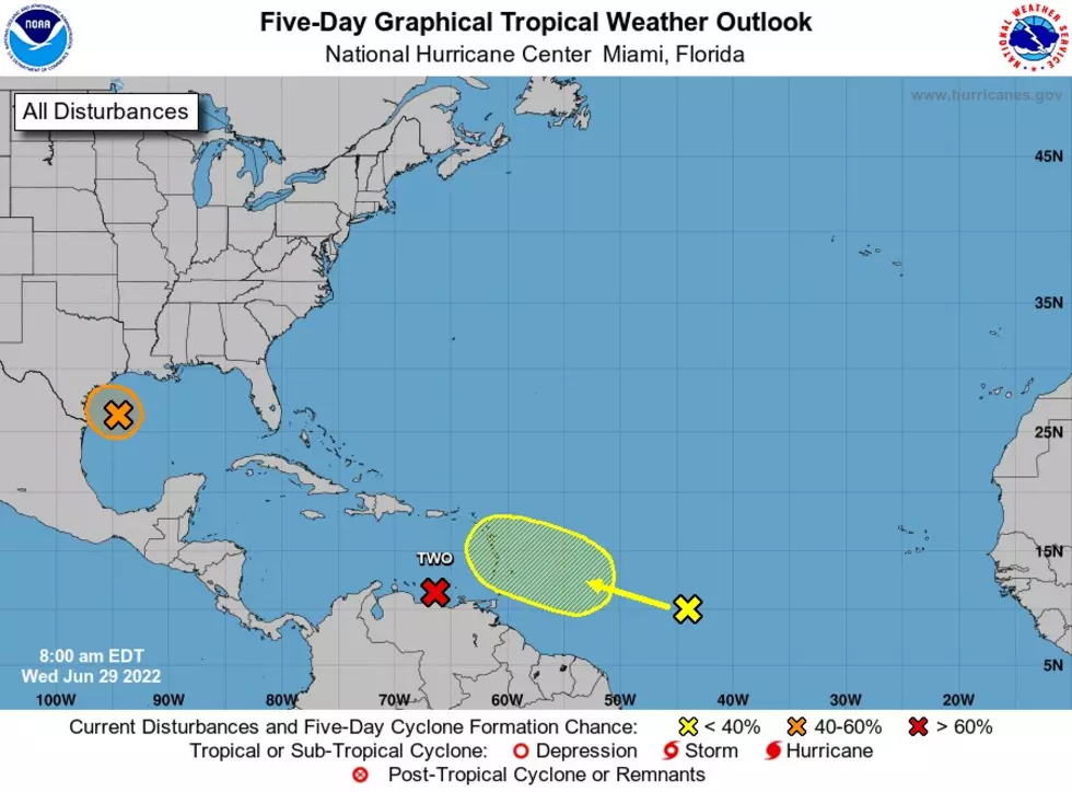
Currently, a disturbance in the northern Gulf of Mexico is being monitored for tropical development. and it could lead to abundant rain later this week and weekend. Right now, it is known as Invest 95-L and it has a chance to become a tropical depression through Thursday. At this point, it really doesn't matter if this strengthens to depression or not. This area will combine with an old frontal boundary will enhance rainfall on parts of the Texas coast through late this week and this weekend. You can check out the latest weather radar for the Gulf of Mexico by visiting Accuweather.com.


Here is what the next few days will look like in Victoria:
Wednesday, June 29th: High 91 Low 73 40 % chance of rain
Thursday, June 30th: High 87 Low 74 60% chance of rain.
Friday, July 1st: High 91 Low 76 60% chance of rain.
During the next few days, continue to expect showers and thunderstorms in the afternoon and evening. The daytime heat is what is causing these storms to erupt at these times.
Even though we are in a drought, we could still possibly see Flash Fooding. Despite the dry conditions in place, there is the possibility that heavy rain could cause localized flooding. The greatest chance of that happening appears to be along the middle and upper Texas coasts through Thursday night.
You also see another area of interest on the above map. We will be watching that area very closely. Be sure you are prepared for Hurricane season. Thes storms sneak up on you.
TIPS: Here's how you can prepare for power outages
More From KLUB Tejano 106.9